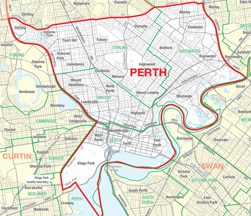
Do I live in the Perth federal electorate?
The federal electorate of Perth is bordered by Karrinyup Road / Morley Drive to the north, Tonkin Highway to the east, the Swan River to the south and the Mitchell Freeway to the west.
See the Australian Electoral Commission’s Find my electorate page for more information.
The following suburbs are in the Perth federal electorate:
- Bedford
- Coolbinia
- East Perth
- Highgate
- Inglewood
- Joondanna
- Leederville
- Maylands
- Menora
- Mount Hawthorn
- Mount Lawley
- North Perth
- Northbridge
- Perth
- Tuart Hill
- West Perth
- Yokine
The following suburbs are partly in the Perth Federal electorate:
- Balcatta (south of Karrinyup Road)
- Bayswater (west of Tonkin Highway)
- Dianella (south of Morley Drive)
- Embleton (west of Tonkin Highway)
- Morley (south of Morley Drive)
- Osborne Park (east of Mitchell Freeway)
- Stirling (south of Karrinyup Road)
What are Community Conversations?
Community Conversations (CC) are small, informal discussion groups where community members come together to share their views on local issues. These conversations help us gather diverse perspectives, understand the concerns of residents, and guide our advocacy efforts.
We are holding regular Community Conversations to hear from the people of Perth, which we will compile into a community listening report, to be released publicly in 2027. If you would like to share your views by attending a Community Conversation contact us here and we will be in touch.